Wucai Qianshan National Waterfront Hiking Fitness Trail (舞彩浅山滨水国家登山步道)
With planned length up to 280km, this trail runs through Beishicao Town, Mulin Town, Longwantun Town, Zhang Town, Dasungezhuang Town.
-
Best Time to Visit:
7-8 hours -
Duration:
All Year -
Admission:
Free Free
Description
Wucai Qianshan National Waterfront Hiking Fitness Trail (舞彩浅山滨水国家登山步道)
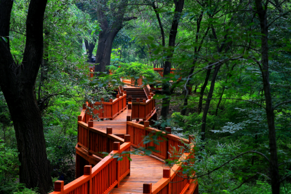
With planned length up to 280km, this trail runs through Beishicao Town, Mulin Town, Longwantun Town, Zhang Town, Dasungezhuang Town. Harboring mountains, waters, scenic areas and fields and gardens, this attraction is built with field footpath, adventure footpath, parent-child footpath, bicycle path and other theme footpaths, forming a structural layout of “main line + small circle line + grand circle line”. Footpaths are respectively themed by earth, slabstone, gravel, wood and lea...
Read MoreWucai Qianshan National Waterfront Hiking Fitness Trail (舞彩浅山滨水国家登山步道)
With planned length up to 280km, this trail runs through Beishicao Town, Mulin Town, Longwantun Town, Zhang Town, Dasungezhuang Town. Harboring mountains, waters, scenic areas and fields and gardens, this attraction is built with field footpath, adventure footpath, parent-child footpath, bicycle path and other theme footpaths, forming a structural layout of “main line + small circle line + grand circle line”. Footpaths are respectively themed by earth, slabstone, gravel, wood and leave, and connect water reservoir, scenic areas, fields, villages and other tourism resources, making tourists indulge themselves in mountains and waters and experience time-honored histories and cultures as well as local customs. Wucai Qianshan National Waterfront Hiking Fitness Trail is committed to creating itself into an urban sport-leisure destination integrating self-drive, bicycle and mountain climbing, and an ideal place for tourists to experience the urban, fashionable yet slow life.
Overview
Length: 125km (in total), including 80km (main line) and 45km (branch line)
Width: 2m
Gradient: 38° (on average); 70° (in maximum)
Altitude: 555m (the lowest)
Pavement Material: Stone steps (14km), wood steps (10km), earth-stone road (50km), gravel road (30km), leaves footpath (20km), plank footpath (1km)
Footpath Type: Outskirt; linear (main line), circular (branch line)
Exercise Intensity: General, medium, high
Target Group: Group at age levels and with physical abilities corresponding to above exercise intensities